Monday, December 20, 2010

Plettenberg Bay Holiday


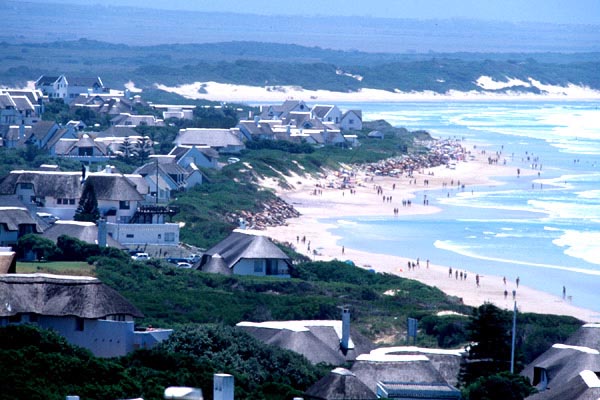
The upmarket holiday town of Plettenberg Bay, about 380 miles (600km) from Cape Town and 125 miles (200km) from Port Elizabeth, was originally called 'Bahia Formosa' (Beautiful Bay) by the early Portuguese explorers, and it is still possible to see why, despite explosive development of luxury homes, hotels and a thriving town center.


The town - familiarly known as 'Plett' - is a favourite holiday destination for South Africans and foreigners with its unspoilt golden beaches, year round Mediterranean climate, dramatic rocky Robberg Peninsula, and vibrant nightlife. The bay is a nursery for the endangered Southern Right Whales, which arrive each winter and spring to calve.


Plettenberg Bay shopping malls and a variety of shops provide everything that is needed by holidaymakers and shoppers, including clothing and speciality goods at several boutiques, arts, crafts, and antiques.
There are plenty of dining opportunities in Plettenberg Bay, from beach pubs, bistros and deli's to five star cuisine and award-winning à la carte menus. Foodies will find Thai, Italian, fresh seafood, steak and a variety of other choices on offer.


The surroundings of Plettenberg Bay provide a playground for sports enthusiasts and the list of activities is almost endless. The lagoon and the bay itself are perfect for all sorts of watersports and activities including boat cruises and sailing, paddling, fishing, swimming and scuba diving, while the beaches allow for long solitary walks.

Between July and December the bay is home to Southern Right Whales that come to calve in the protected waters. The mountains and forests offer a variety of trails for hikers, mountain bikers and horse riders on holiday. Plett's golf courses are also highly regarded and provide plenty of challenges.
There are thirteen polo grounds in and around Plettenberg Bay; the best known is at Kurland (20 minutes outside the town, heading towards Port Elizabeth) where major polo tournaments take place over Christmas and Easter.

Saturday, December 18, 2010

Pilanesberg National Park, North West Province

The Pilanesberg National Park, which covers some 55 000 hectare, is the fourth largest in southern Africa. This malaria-free park is perched on the eroded vestiges of an alkaline volcanic crater - one of only three such craters in the world.


The history of the Pilanesberg Park is also unique amongst national parks in South Africa. Pilanesberg National Park's special features of rugged landscape, well-watered valleys and attractive dwelling sites have made it a preferred site for human settlement for thousands of years. Prior to its proclamation as a reserve in 1979, the Pilanesberg National Park Complex was degraded and depleted of indigenous wildlife populations due to fairly intense settlement by commercial farmers. At considerable expense, the land has been restocked with game, the scars of human settlement were removed and tourism infrastructure was developed during the first 15 years (1979 and 1993). This constituted the largest and most expensive game stocking and land rehabilitation project ever undertaken in any African game reserve at the time.


A 110 kilometre peripheral Big Game fence was erected over some very rugged terrain, 188 kilometre of visitor roads have been developed and more than 6 000 head of game were introduced during the Operation Genesis game translocation programme. Thus, while wildlife resources are rapidly declining in most developing countries in Africa, Pilanesberg National Park is one of the few areas where this trend has been dramatically reversed. For this far-sighted action the North West Province (Previously Bop Parks) and its people have received worldwide acclaim and recognition. The challenge that lies ahead is to further develop and manage Pilanesberg National Park in such a way that the conservation, cultural, recreational and economic benefits of this far-sighted action can be optimally utilised to the benefit of current and future generations.


Pilanesberg exists within the transition zone between the dry Kalahari and wetter Lowveld vegetation, commonly referred to as "Bushveld". Unlike any other large park, unique overlaps of mammals, birdlife and vegetation occur because of this transition zone. Springbok, brown hyaena, the redeyed bulbul, and camel thorn trees usually found in arid areas are found co-habitating with moist-area-limited impala, blackeyed bulbul and Cape chestnut trees. Pre-sunrise and post-sunset drives are possible owing to gate opening and closure times.

Since late 1979, thanks to Operation Genesis - the largest game translocation ever undertaken at the time, tourists have been able to take note of nature's alphabet - from aardvark to zebra. The park boasts healthy populations of lion, leopard, black and white rhino, elephant and buffalo - Africa's "Big Five". A wide variety of rare and common species exist with endemic species like the nocturnal brown hyaena, the fleet-footed cheetah, the majestic sable, as well as giraffe, zebra, hippo and crocodile, to mention but a few.


Geologically, the area is world famous. Its structure, termed the "Pilanesberg National Park Alkaline Ring Complex" was formed by volcanic eruptions some 1 200 million years ago. Apart from its unique size, shape and rock types, the volcanic origin and resultant weathering of the extinct crater has resulted in a wide variety of landscapes. This provides some of the most spectacular scenery in Southern Africa. It also provides a wide range of habitats for game animals. Because of this, Pilanesberg National Park has the potential to carry a wider variety of game species than any other similar sized game reserve in Southern Africa. Its potential for supporting rare and endangered species such as black rhino, roan, sable, tsessebe, foot-and-mouth free buffalo and wild dogs is particularly high. As well as the 'Big Five' you will find the nocturnal brown hyena, cheetah, hippo, crocodile and even sable.

How to Grow a Herb Lawn


Pilanesberg National Park

Thursday, December 16, 2010

Voortrekker Monument Pretoria


The Voortrekker Monument Pretoria stands over 40 meters tall on its hilltop home, and is visible from a large part of Pretoria.


It was built to describe the history of the Afrikaner pioneers (called Voortrekkers) who left the Cape Colony, where they suffered under British rule, to travel to the interior of the country from 1835 to 1854 on what has come to be known as the Great Trek.


Both within and around the monument, every aspect of the building has a historic or symbolic significance.
A unique marble Frieze circles the inside walls of the Voortrekker Monument. In bas-relief, 27 panels depict the story of the Great Trek from 1835 to 1852. The Frieze not only shows the history of the Great Trek, but also shows how the Voortrekkers went about their everyday lives. It also provides an insight on their religious beliefs and work methods of the Voortrekkers and historic wars, such as the Battle of Bloodriver.


Cenotaph Hall is located on the lower floor, and is home to the Cenotaph (empty tomb).
On 16 December every year the sun shines down through a small hole in the centre of the Voortrekker Monument roof, onto the Cenotaph, lighting up the enscribed words: "Ons vir jou Suid Africa" ("We for thee, South Africa"). 


Many thousands of South African's travel from a far for this special memorial event.

"Ons is kinders van die Groot Trek
'n Nasie enig in sy soort!"

Wednesday, December 15, 2010

Soutpansberg Region, Limpopo


Lying in the northern part of the Limpopo, bordering on both Botswana and Zimbabwe, the Vhembe Region is nothing short of spectacular - the baobab, a familiar symbol that stands resolute among the magnificence of vast expanses of indigenous bush in a land characterised by the myth and legend of the Venda people and awash with the vivid colour of blue skies, a prolific wildlife and seemingly endless opportunities for exploration.


In the west of the Vhembe Region lie the craggy peaks that form the jagged spine of the Soutpansberg or ‘salt pan mountain’, which attributes its name to the giant salt pan on the west side of this range that has been a source of salt for centuries. Cross the mountain range and one falls into the all-encompassing plains of the Limpopo Valley, which stretches across the north of the country, characterised by further glimpses of the giant baobab and recurrent mopane trees.


Through this natural basin flows the Limpopo River, the country’s third most important river and a life source for the essentially hot, dry land through which it winds, giving life to more than 500 tree species, a series of farming villages and one of the world’s highest concentrations of leopard. Another important river to the region is the Nzhelele, which flows from its source on the eastern slopes of the Soutpansberg to slice its way into the Limpopo just east of Musina.


To the east lie the Lowveld and Kruger National Park, most of which falls into the Limpopo whilst to the south is the ‘land of legend’, a region that lays claim to a sacred lake, holy forest where ancient ways are still revered by traditional Venda culture. 


The Mapungubwe and the Makapane Valley are both national heritage sites, and a feast of lion, leopard, white and black rhino, elephant, cheetah and spotted hyena - most of the continent’s big game - roam here. It is rich in cultural heritage and boasts an incredible diversity of plant and animal life, but what draws visitors time and time again are the incredible unspoilt wilderness areas that seamlessly contrast with sophisticated resorts to provide warm hospitality in a destination without equal.

Monday, December 13, 2010

Richards Bay


Richards Bay is one of South Africa's biggest ports boasting the largest export coal terminal in the world, loading 65 million tons every year, and is situated on the 12 square mile (30 sq km) lagoon of the Mhlatuze River. It began as a makeshift harbour that was set up during the Anglo-Boer War of 1879 and is named after its founder, Sir Frederick Richards. The specialised ships that call are a must-see for maritime buffs. The town is a bustling business centre featuring every modern facility and offers plenty of recreational facilities for visitors.


Besides the rapid industrial expansion, Richards Bay's tourism industry is thriving and it is fast becoming one of the north coast holiday destinations with spectacular scenery on offer and pristine golden beaches which are gently lapped by the warm waters of the Indian Ocean. It is a popular kite-surfing destination as the area has good consistent winds blowing from the north-east and highly ranked kite-surfers are regular visitors to this town. Tourists can enjoy plenty of other adventurous activities such as fishing, yachting and kayaking. Humpback dolphins and whales are frequent visitors to the waters around Richards Bay and can be viewed from a specially erected viewing point at Alkantstrand Beach.


Richards Bay offers tourists entrance to the once forgotten corner of Africa that is Zululand, a place of exquisite beauty and diversity. A multitude of game reserves are within an hour or two's drive of Richards Bay. Hluhluwe Umfolozi Park is a must-see for nature lovers, featuring the 'big five' (elephants, lions, leopards, buffalo and rhinos) as well as cheetahs, wild dogs and nyala.


 Lake Mzingazi, the primary water supply of Richards Bay, is a popular tourist attraction offering visitors the chance to view Nile crocodiles and hippos as well as over 350 species of birds, making it a bird watcher's paradise. Richards Bay's surrounds have vast expanses of untouched and unspoilt indigenous vegetation as well as natural lakes and marshes, making it one of the most picturesque tourist destinations in the country.

Engela

How to Make a Summer Christmas Pudding

Saturday, December 11, 2010

South Africa Wedding and Honeymoon


A wedding and honeymoon in South Africa is unforgettable. Its beautiful weather and friendly people are enjoyable at a variety of romantic wedding and honeymoon settings; from forests on the Garden Route to stunning beaches in KwaZulu-Natal, or the wilds of the Kruger National Park and surrounds. Cape Town is another beautiful wedding or honeymoon destination, perhaps even the best due to its variety of attractions, cultures and facilities. There are various hotels, lodges and holiday resorts in South Africa that provide unique wedding and honeymoon venues.


A wedding or honeymoon couple in South Africa will find many intriguing things to see and do. In Cape Town, visit the world-famous Table Mountain or Nelson Mandela's Robben Island. Travelling through the Garden Route, the Knysna waterfront and lagoon or the Tsitsikamma Rainforest is worth exploring, as are some of the many coastal dive sites. 


The water gets warmer further up the coast and there are lovely beach towns to visit in the Transkei and KwaZulu-Natal. And of course, the Kruger National Park is undoubtedly a truly African 'Big 5' experience!


Couples wishing to get married in South Africa will need to provide identity documents and birth certificates. If either party is not a resident of South Africa, they will need to show a valid passport. Two witnesses need to be present at the wedding, with their identity documents, to sign the marriage register. Civil marriages in South Africa can only be officiated by an authorized marriage officer. The South African Department of Home Affairs has detailed marriage information for couples.


Engela

Friday, December 10, 2010

St. Francis Bay

St. Francis Bay is a picturesque holiday village laying at the gateway to the Garden Route, one of South Africa's premier holiday destinations and an hour's drive from the city of Port Elizabeth.


First sighted in 1575 by a Portuguese sailor, he named the area, St. Francis, after the Patron Saint of Sailors. The climate is temperate with warm summers and mild winters. The Kromme River borders the one side of St. Francis Bay, and is navigable for 6 miles (10km) upstream from the river mouth.

The river and its mouth is popular with fishermen, boaters, canoeists, windsurfers, kite surfers and marine creatures which shelter in its waters. Linked to the river is a magnificent marina lined with white walled thatched homes, some of which offer bed and breakfast accommodation. Canal cruises at sunset are popular here or else one can enjoy drinks or a meal at a Restaurant overlooking the canals.


 Port St. Francis, a small harbour resort village, lies in a sheltered nook of the bay and provides a colourful setting and safe anchorage for calamari boats, pleasure craft, and ocean going yachts. Cape St. Francis, a rustic fishing village, sits adjacent to St. Francis Bay. Popular for surfing at Seal Point, its beautiful stretch of beach and historic lighthouse built in 1878. Walking trails wind along the rocky coast, through the Irma Booysen Floral Reserve, and along the Cape St. Francis Point, linking it to the village of St. Francis Bay.
The village has several small shops and art galleries that will cater to almost all your needs and ensure that you find some souvenirs to take back home. There are two fair sized supermarkets which will provide all your basic requirements. In high season most of the shops are open seven days a week.


Whales can be spotted in the Bay from May to late October and dolphins can be seen daily on their way back and forth between the Bays of Cape St. Francis and Jeffrey's Bay. The Cape Clawless Otter is also ever present, frolicking in the waves and rock pools around the Port of St. Francis area and at Otters Landing.


 Nature lovers can enjoy the hiking trails meandering through the nature reserves and along a dune river system, with its unique landscape, where you can view the area's "Fynbos" (fine leafed indigenous plants) and see antelope roam freely. Over 200 species of birds have been recorded including the rare African Oyster Catcher and magnificent Fish Eagle. St. Francis Bay also has two 18 hole golf courses, St. Francis Bay Golf Course and the St. Francis Links, a Jack Nicklaus Signature Course. The Addo Elephant Park, situated in a malaria free area is a mere hour and a quarter's drive from St. Francis Bay and offers the best elephant viewing in the world.

Engela

The Top Five Music Albums By Neil Diamond

Tuesday, December 7, 2010

Valley of a 1000 Hills, KwaZulu Natal


The Valley of 1000 Hills Route is one of KwaZulu Natal's best kept secrets. The Valley of a 1000 Hills forms around the majestic valley created by the Mngeni River and its tributaries. Many artists and crafters have been attracted to the beauty and tranquillity of this area which is dotted with cozy guest lodges, friendly pubs and tea gardens with sweeping views over the hills and dams.


The main attractions on the 1000 Hills Experience are the dramatic landscape and Zulu culture which is well interpreted at three cultural villages.


The 1000 Hills Choo- Choo offers steam train trips from Kloof station to Cato Ridge on weekends and the more adventurous can view the stunning scenery from the skies. Microlight flips are organised from Cato Ridge Airfield.


 There are also boat cruises on Shongweni, Nagle and Inanda Dams and visitors can spend a day on a fishing trip or escorted 4 wheel drives through the Valley Floor.

Engela

Monday, December 6, 2010

Foot Safaris in the Kruger National Park

Foot safaris offer you unforgettable encounters with creatures both great and small. From stalking a herd of Giraffe to discovering the mysteries of a Termite mound, these experiences become far more meaningful when you feel Africa through the soles of your feet. There is something extremely humbling about sizing up a White Rhino who is glaring at you and wondering whether there is a tree close enough to scale out of danger …


A professional guide will brief you fully on the “do’s & don’ts” before you set off, to ensure safety and a rewarding walk. He will instruct you to tune all your senses, because each and every one of them will come into play during the next few hours. The ramble will focus on the patterns of nature, the intricacies of stalking, the inter-dependant relationships of organisms and, along the way, your trail leader with demonstrate his encyclopaedic knowledge of mammals, birds, plants plus any other item of interest that you may stumble upon … including Big Game!


The walk doesn’t focus on how far you can go but rather what you can absorb – the beauty of birdsong, the frenetic activity of Harvester Ants collecting seeds or the patience of a Green-backed Heron as it hunts for fish.


Brief rest periods become productive as you discuss issues that have come up – it’s amazing what putting one foot in front of the other along a game path does to clear the mind. The twinge of adrenaline also heightens the senses.


And there is always a need for adrenaline – the “fight or flee” response is bubbling at the surface. However, a good guide will put everyone at ease because he is so in tune with the bush and his surroundings that his confidence exudes calmness. The local Shangaan Ranger team has been living in this environment cheek by jowl with these animals their whole life, so the only unknown for them are the trailists that they are leading. Their collective stories would fill a journal and their observations come not from formal education but their own experiences and shared stories. When they discuss the medicinal properties of a tree, bush or shrub, you can rest assured that they have used it themselves. When they describe the uses of a piece of wood, be sure that they have put it to good use before.

So, therefore, time spent on foot in a Wilderness area is the very embodiment of a memorable safari experience. 

Sunday, December 5, 2010

Kalahari, Northern Cape

The portion of the great Kalahari desert that lies in the Northern Cape is but part of a large arid to semi-arid sandy area known as the Kalahari Basin, covering 2.5 million square kilometres that stretch from the Orange River to cover most of Botswana and parts of Namibia. It evokes a picture of never ending red sand dunes, big, blue skies and a scorching sun that shimmers unrelentingly on ancient dry riverbeds, known as omuramba.
 

The Kalahari, derived from the Tswana Kgala, which means ‘great thirst’ or ‘waterless place’ is a vast area of red sand dunes, the southern part of which dominates the Northern Cape. Yet set along the border with the North West province are the mostly unfamiliar mining towns and villages of Black Rock, Dibeng, Kathu, Van Zylsrus, Hotazel, Dingleton, Olifantshoek and Kuruman. The Kalahari is both deceptive and alluring. Deceptive because beneath the surface of apparent desert lies an incredible wealth of iron, manganese and other precious ores, which explains the mining towns, and alluring for visitors because of the many game farms and nature reserves to which the Kalahari is home.


Despite the wilderness, the Kalahari is not true desert in the sense of being unable to support life. Parts of the Kalahari receive as much as 250 millimetres of rainfall, albeit erratically, throughout the year, and grasses and acacias easily support large species of antelope, hyenas, lions, meerkats, giraffe, warthogs and jackals.


Nature Reserves like the beautiful Witsand Nature Reserve, with its famous ‘roaring sands’ of the Kalahari - dunes that emit a rather uncanny rumble when disturbed – and Tswalu Kalahari Reserve, surrounded by the beautiful Koranneberg Mountains on the edge of the Kalahari, one of the largest private game reserves in the country, are part of the allure of the Kalahari.


Engela

Friday, December 3, 2010

Sunshine Coast, Eastern Cape


Sunshine Coast is an apt description of a coastal belt beset with countless little villages, each offering access to beaches, rivers, lagoons and hiking trails that stretches between the Tsitsikamma and East London in the Eastern Cape.


As a destination the Sunshine Coast has had to do little to attract visitors. Its obviously glorious weather, the seaside-resorts of Kenton-on-Sea and Port Alfred - considered the heart of this stretch of coastline - St Francis Bay, Cape St Francis, Jeffreys Bay and their access to warm waters, water sports, eco-walks, friendly locals, sheltered coves, rock pools and nature reserves, makes its attraction blatantly obvious. Add to this the inland malaria-free ‘Big Five’ access on local game farms, and easy access to the Great Fish River, the Wild Coast and the Addo Elephant Park, and it is easy to understand why so many Capetonians head this way during their rather wet winters, and the rest of the country, as well as visitors to the Eastern Cape, make this their playground.


A major reason for heading for the Sunshine Coast is that despite its obvious attraction, it remains largely unspoiled and, for the most part, un-commercialised. A number of places around the world are called the Sunshine Coast - Queensland in Australia, Bay of Plenty in New Zealand; even Essex in the UK - but none of them manage to retain the quintessential sun-drenched essence without losing any of their quaintness the way the Sunshine Coast in the Eastern Cape does.


Thursday, December 2, 2010

Hartbeespoort Dam, North West Province


Roughly 45 minutes' drive from Johannesburg and Pretoria, surrounded by the beautiful Magaliesberg mountain range, Hartbeespoort Dam, or Harties to locals, has become a hive of activity and is a very popular weekend getaway for the two cities.


The beauty of Hartbeespoort Dam is what draws people here - the dam literally cradled in the lap of the mountains - and many regard this as a retreat from the concrete jungle of city living. The 1620 hectare Hartbeespoort Dam functions both as a source of irrigation for farms in the area and as a resort, and the peace of the hills and valleys, the warmth even on winter days and the charm of the surrounding countryside, make this a place to restore the soul.


Take the scenic road from Johannesburg to Hartbeespoort, along curving roads that meander between aloes in flower during the winter months, and you're sure to pass the breakfast run of Harley-Davidsons - their drivers part of the Jo'burg exec set hell bent on nothing more than enjoying their machines in the sunshine.
The Hartbeespoort Dam offers an array of water sports, a local bird sanctuary, challenging hikes and gentle rambles. 


There is a collection of restaurants in Hartbeespoort that range from Tan' Malie se Winkle, a local institution where you can eat to your heart's content on traditional Afrikaans home-cooked meals, to the local Pick-a-Pancake, which takes pancakes into a new league. This restaurant lies literally in the heart of the Welwitschia Market - a range of African arts, crafts, novelties, curios and other at the four-way crossing at Hartbeespoort that makes a visit here imperative.

Remember to visit Woman To Woman!

Engela

Wednesday, December 1, 2010

Suikerbosrand Nature Reserve, Gauteng

Situated close to Johannesburg, one of South Africa's most densely populated areas, the Suikerbosrand Nature Reserve plays an important role in outdoor recreation, environmental education and resource management.


Covering approximately 13,337 ha of kloofs, ridges and plains, the Suikerbosrand reserve supports a large variety of plant and animal species. Vegetation types range from open grassland on hillsides and plains to wooded gorges and acacia woodland, marshland and fynbos (heath). The reserve was named after the Sugarbush (suikerbos), which is spread throughout the reserve. The fast disappearing bankenveld grassland also occurs here, making this one of the Highveld's most valuable reserves.


Mammal species include mountain reedbuck, common duiker and steenbok, grey duiker, baboon, oribi, eland, blesbok, springbok, red hartebeest, black wildebeest, kudu and zebra. Predators roaming this vast sanctuary are cheetah, brown hyena and other smaller species.


Over 200 South African birds can be observed here. A network of hiking trails, covering approximately 66km in total, allows visitors to get a closer look at the diversity of plant and animal life. The trails vary in length from 1 to 6 days, day walks of 10 or 17 km long and a 4,5 km trail. For the less energetic there is a 60km game-viewing route.


Visitors should stop by the information centre at Diepkloof in the northern section of the reserve. Here they can relax at various picnic spots or attend one of the slide or film shows.


Engela