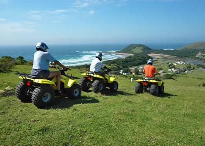
The Kosi Bay Nature Reserve is situated on the coast in the northern part of KwaZulu Natal and surrounds the Kosi Bay lake system. The system consists of four lakes and a series of inter-connecting channels which drain via a sandy estuary into the Indian Ocean. It is home to a variety of birds and wildlife including hippopotamus and crocodile.
This is the most pristine lake system on the South African Coast. The 11, 000 hectare Kosi Bay Nature Reserve is a tropical paradise of crystal-clear blue water and marshland, raffia, wild date and palm, mangrove swamp and sycamore fig forest that combine to provide a home for approximately 250 species of bird, among them the fish eagle and palmnut vulture, white backed heron and the night heron as well as purple and reed kingfisher.
Bushbuck, duiker and monkey inhabit the forested parts whilst hippopotamus and crocodile bask in and around the lakes and fish teem beneath their surfaces. Humpback whales can be seen off the beaches on their northerly migration to calve in Mozambique and in December and January loggerhead and leatherback turtles come onto the beaches to lay their eggs in carefully prepared nests.
Please be aware that Kosi Bay is a high risk malaria area and visitors are advised to take precautions. Please consult your Doctor or Pharmacist about malaria prophylaxis prior to visiting the Kosi Bay Nature Reserve.
In the heart of the Wild Coast is Coffee Bay, a small inlet near Mthata with only a grocery store, post office, and a few Bed and Breakfast establishment and backpackers to its name.
The destination largely appeals to students and the young at heart, and the nightlife consists of drumming circles and the occasional trance parties.
What Coffee Bay boasts of, however, is some of the best surfing in South Africa along with spearfishing, scuba diving, and swimming, on an unspoiled stretch of coastline. There is fishing to be done, and you'll likely spot dolphins, whales, and the occasional Cape Clawless Otter.
The area is a paradise for hiking, horseback riding and golf. Although distinctive landmarks are few, don't miss the iconic Hole-in-the-Wall, a remarkable rock that has had a giant tunnel carved into it by the sea.
This is paradise! This is a must see to appreciate!!
The upmarket holiday town of Plettenberg Bay, about 380 miles (600km) from Cape Town and 125 miles (200km) from Port Elizabeth, was originally called 'Bahia Formosa' (Beautiful Bay) by the early Portuguese explorers, and it is still possible to see why, despite explosive development of luxury homes, hotels and a thriving town center.
The town - familiarly known as 'Plett' - is a favourite holiday destination for South Africans and foreigners with its unspoilt golden beaches, year round Mediterranean climate, dramatic rocky Robberg Peninsula, and vibrant nightlife. The bay is a nursery for the endangered Southern Right Whales, which arrive each winter and spring to calve.
Plettenberg Bay shopping malls and a variety of shops provide everything that is needed by holidaymakers and shoppers, including clothing and speciality goods at several boutiques, arts, crafts, and antiques.
There are plenty of dining opportunities in Plettenberg Bay, from beach pubs, bistros and deli's to five star cuisine and award-winning à la carte menus. Foodies will find Thai, Italian, fresh seafood, steak and a variety of other choices on offer.
The surroundings of Plettenberg Bay provide a playground for sports enthusiasts and the list of activities is almost endless. The lagoon and the bay itself are perfect for all sorts of watersports and activities including boat cruises and sailing, paddling, fishing, swimming and scuba diving, while the beaches allow for long solitary walks.
Between July and December the bay is home to Southern Right Whales that come to calve in the protected waters. The mountains and forests offer a variety of trails for hikers, mountain bikers and horse riders on holiday. Plett's golf courses are also highly regarded and provide plenty of challenges.
There are thirteen polo grounds in and around Plettenberg Bay; the best known is at Kurland (20 minutes outside the town, heading towards Port Elizabeth) where major polo tournaments take place over Christmas and Easter.
The Pilanesberg National Park, which covers some 55 000 hectare, is the fourth largest in southern Africa. This malaria-free park is perched on the eroded vestiges of an alkaline volcanic crater - one of only three such craters in the world.
The history of the Pilanesberg Park is also unique amongst national parks in South Africa. Pilanesberg National Park's special features of rugged landscape, well-watered valleys and attractive dwelling sites have made it a preferred site for human settlement for thousands of years. Prior to its proclamation as a reserve in 1979, the Pilanesberg National Park Complex was degraded and depleted of indigenous wildlife populations due to fairly intense settlement by commercial farmers. At considerable expense, the land has been restocked with game, the scars of human settlement were removed and tourism infrastructure was developed during the first 15 years (1979 and 1993). This constituted the largest and most expensive game stocking and land rehabilitation project ever undertaken in any African game reserve at the time.
A 110 kilometre peripheral Big Game fence was erected over some very rugged terrain, 188 kilometre of visitor roads have been developed and more than 6 000 head of game were introduced during the Operation Genesis game translocation programme. Thus, while wildlife resources are rapidly declining in most developing countries in Africa, Pilanesberg National Park is one of the few areas where this trend has been dramatically reversed. For this far-sighted action the North West Province (Previously Bop Parks) and its people have received worldwide acclaim and recognition. The challenge that lies ahead is to further develop and manage Pilanesberg National Park in such a way that the conservation, cultural, recreational and economic benefits of this far-sighted action can be optimally utilised to the benefit of current and future generations.
Pilanesberg exists within the transition zone between the dry Kalahari and wetter Lowveld vegetation, commonly referred to as "Bushveld". Unlike any other large park, unique overlaps of mammals, birdlife and vegetation occur because of this transition zone. Springbok, brown hyaena, the redeyed bulbul, and camel thorn trees usually found in arid areas are found co-habitating with moist-area-limited impala, blackeyed bulbul and Cape chestnut trees. Pre-sunrise and post-sunset drives are possible owing to gate opening and closure times.
Since late 1979, thanks to Operation Genesis - the largest game translocation ever undertaken at the time, tourists have been able to take note of nature's alphabet - from aardvark to zebra. The park boasts healthy populations of lion, leopard, black and white rhino, elephant and buffalo - Africa's "Big Five". A wide variety of rare and common species exist with endemic species like the nocturnal brown hyaena, the fleet-footed cheetah, the majestic sable, as well as giraffe, zebra, hippo and crocodile, to mention but a few.
Geologically, the area is world famous. Its structure, termed the "Pilanesberg National Park Alkaline Ring Complex" was formed by volcanic eruptions some 1 200 million years ago. Apart from its unique size, shape and rock types, the volcanic origin and resultant weathering of the extinct crater has resulted in a wide variety of landscapes. This provides some of the most spectacular scenery in Southern Africa. It also provides a wide range of habitats for game animals. Because of this, Pilanesberg National Park has the potential to carry a wider variety of game species than any other similar sized game reserve in Southern Africa. Its potential for supporting rare and endangered species such as black rhino, roan, sable, tsessebe, foot-and-mouth free buffalo and wild dogs is particularly high. As well as the 'Big Five' you will find the nocturnal brown hyena, cheetah, hippo, crocodile and even sable.
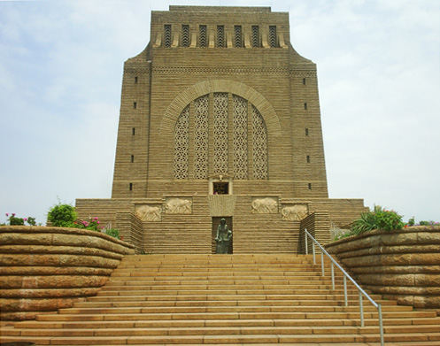
The Voortrekker Monument Pretoria stands over 40 meters tall on its hilltop home, and is visible from a large part of Pretoria.
It was built to describe the history of the Afrikaner pioneers (called Voortrekkers) who left the Cape Colony, where they suffered under British rule, to travel to the interior of the country from 1835 to 1854 on what has come to be known as the Great Trek.
Both within and around the monument, every aspect of the building has a historic or symbolic significance.
A unique marble Frieze circles the inside walls of the Voortrekker Monument. In bas-relief, 27 panels depict the story of the Great Trek from 1835 to 1852. The Frieze not only shows the history of the Great Trek, but also shows how the Voortrekkers went about their everyday lives. It also provides an insight on their religious beliefs and work methods of the Voortrekkers and historic wars, such as the Battle of Bloodriver.
Cenotaph Hall is located on the lower floor, and is home to the Cenotaph (empty tomb).
On 16 December every year the sun shines down through a small hole in the centre of the Voortrekker Monument roof, onto the Cenotaph, lighting up the enscribed words: "Ons vir jou Suid Africa" ("We for thee, South Africa").
Many thousands of South African's travel from a far for this special memorial event.
Lying in the northern part of the Limpopo, bordering on both Botswana and Zimbabwe, the Vhembe Region is nothing short of spectacular - the baobab, a familiar symbol that stands resolute among the magnificence of vast expanses of indigenous bush in a land characterised by the myth and legend of the Venda people and awash with the vivid colour of blue skies, a prolific wildlife and seemingly endless opportunities for exploration.
In the west of the Vhembe Region lie the craggy peaks that form the jagged spine of the Soutpansberg or ‘salt pan mountain’, which attributes its name to the giant salt pan on the west side of this range that has been a source of salt for centuries. Cross the mountain range and one falls into the all-encompassing plains of the Limpopo Valley, which stretches across the north of the country, characterised by further glimpses of the giant baobab and recurrent mopane trees.
Through this natural basin flows the Limpopo River, the country’s third most important river and a life source for the essentially hot, dry land through which it winds, giving life to more than 500 tree species, a series of farming villages and one of the world’s highest concentrations of leopard. Another important river to the region is the Nzhelele, which flows from its source on the eastern slopes of the Soutpansberg to slice its way into the Limpopo just east of Musina.
To the east lie the Lowveld and Kruger National Park, most of which falls into the Limpopo whilst to the south is the ‘land of legend’, a region that lays claim to a sacred lake, holy forest where ancient ways are still revered by traditional Venda culture.
The Mapungubwe and the Makapane Valley are both national heritage sites, and a feast of lion, leopard, white and black rhino, elephant, cheetah and spotted hyena - most of the continent’s big game - roam here. It is rich in cultural heritage and boasts an incredible diversity of plant and animal life, but what draws visitors time and time again are the incredible unspoilt wilderness areas that seamlessly contrast with sophisticated resorts to provide warm hospitality in a destination without equal.
Richards Bay is one of South Africa's biggest ports boasting the largest export coal terminal in the world, loading 65 million tons every year, and is situated on the 12 square mile (30 sq km) lagoon of the Mhlatuze River. It began as a makeshift harbour that was set up during the Anglo-Boer War of 1879 and is named after its founder, Sir Frederick Richards. The specialised ships that call are a must-see for maritime buffs. The town is a bustling business centre featuring every modern facility and offers plenty of recreational facilities for visitors.
Besides the rapid industrial expansion, Richards Bay's tourism industry is thriving and it is fast becoming one of the north coast holiday destinations with spectacular scenery on offer and pristine golden beaches which are gently lapped by the warm waters of the Indian Ocean. It is a popular kite-surfing destination as the area has good consistent winds blowing from the north-east and highly ranked kite-surfers are regular visitors to this town. Tourists can enjoy plenty of other adventurous activities such as fishing, yachting and kayaking. Humpback dolphins and whales are frequent visitors to the waters around Richards Bay and can be viewed from a specially erected viewing point at Alkantstrand Beach.
Richards Bay offers tourists entrance to the once forgotten corner of Africa that is Zululand, a place of exquisite beauty and diversity. A multitude of game reserves are within an hour or two's drive of Richards Bay. Hluhluwe Umfolozi Park is a must-see for nature lovers, featuring the 'big five' (elephants, lions, leopards, buffalo and rhinos) as well as cheetahs, wild dogs and nyala.
Lake Mzingazi, the primary water supply of Richards Bay, is a popular tourist attraction offering visitors the chance to view Nile crocodiles and hippos as well as over 350 species of birds, making it a bird watcher's paradise. Richards Bay's surrounds have vast expanses of untouched and unspoilt indigenous vegetation as well as natural lakes and marshes, making it one of the most picturesque tourist destinations in the country.